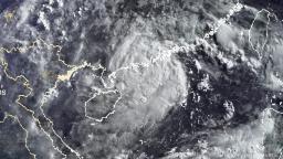
Two major storms form in East Asia, threatening China, Japan and Taiwan


Cempaka is not expected to intensify as it nears land. A Strong Wind Signal No. 3 was in effect for Hong Kong, indicating wind speeds of 41 to 62 kph (about 25-40 mph), according to the Hong Kong Observatory’s typhoon warning signals.
The other storm, In-Fa, is tracking further north, mainly impacting Japan’s southern islands and Taiwan. It is forecast to strengthen into a typhoon Tuesday night, but it is not likely to interact with Cempaka.
In-Fa is expected to bring rain to Japan ahead of the Olympic Games, which open in Tokyo on Friday. The big waves associated with the storm may be a boon for surfers training for the inaugural Olympic surfing competition.
Cempaka is expected to make landfall Tuesday afternoon or evening near the city of Yangjiang in China’s Guangdong province, bringing heavy, flooding rains to southeastern portions of the country through much of this week.
A widespread 100 to 200 millimeters (about 4 to 8 inches) of rainfall is forecast for the provinces of Guangdong, Guangxi and Hainan. Isolated locations could approach 500 millimeters (about 20 inches) through Friday local time. There will also be strong, gusty winds, especially near the coast where the storm will make landfall, which could cause isolated power outages.
The Joint Typhoon Warning Center said it expects Cempaka to meander over these provinces and possibly emerge back over the South China Sea by this weekend, keeping an elevated risk for rain and flooding, especially near the coast.
Powerful typhoons are a regular occurrence during the summer in southern China, though they can form throughout the year due to the warm waters of the Pacific. So, unlike the Atlantic hurricane season, the West Pacific typhoon season doesn’t have a defined beginning and end.


