
Typhoon Maysak: Forecast to strengthen as it moves toward Japan, the Korean Peninsula

If it makes landfall in the Korean Peninsula, it would be the fourth named storm to do so this year.
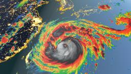
Unfortunately for parts of Japan and South Korea, Typhoon Maysak is a significantly stronger system than Bavi was. And further strengthening is expected before its initial landfall on Tuesday morning.
Maysak is forecast to strengthen to a potential Category 4 equivalent hurricane, with winds of 220 kph as it barrels across Japan’s Ryukyu Islands.
The system will be dangerously close to the city of Okinawa by early Tuesday and has already prompted significant air travel disruptions in the region.
Maysak, a name of Cambodian origin for a type of tree, is forecast to weaken only slightly as it nears a second landfall west of Busan, South Korea, sometime late Wednesday afternoon.
Winds are forecast to be near 200 kph (124 mph), strong enough to designate it a major Category 3 hurricane if it were in the Atlantic Ocean.
The threat of dangerous storm surge and landslides in the Korean Peninsula’s elevated terrain is a significant concern.
After all, the region is currently experiencing one of its wettest monsoons on record. Several bouts of historic rains have soaked the landscape since June.
Long-range forecast computer models suggest another potentially powerful typhoon could impact the region late this weekend or early next week.